
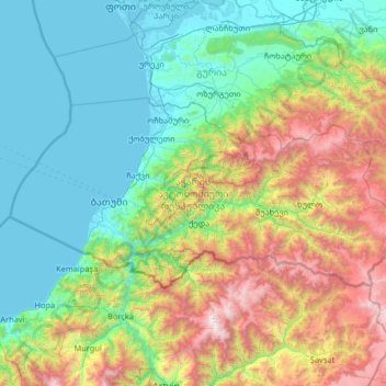
Autonomous Republic of Adjara topographic map
Interactive map
Click on the map to display elevation.
Autonomous Republic of Adjara topographic map, elevation, terrain
About this map
Name: Autonomous Republic of Adjara topographic map, elevation, terrain.
Location: Autonomous Republic of Adjara, Georgia (41.43057 41.29944 41.91193 42.60272)
Average elevation: 802 m
Minimum elevation: -2 m
Maximum elevation: 3,345 m
Other topographic maps
Click on a map to view its topography, its elevation and its terrain.
Tbilisi
Most of the raions are named after historic quarters of the city. The citizens of Tbilisi widely recognise an informal system of smaller historic neighbourhoods. Such neighbourhoods are several, however, constituting a kind of hierarchy, because most of them have lost their distinctive topographic limits. The…
Average elevation: 756 m