
Southern District topographic map
Interactive map
Click on the map to display elevation.
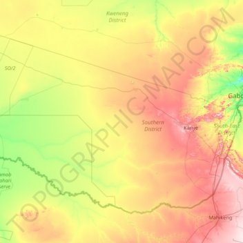
Southern District topographic map, elevation, terrain
Southern District
In the south, Southern borders the North West Province of South Africa. Domestically, it borders South-East District in east, Kweneng District in north, Kgalagadi District and south west. Southern District is traversed by the northwesterly line of equal latitude and longitude. Most part of Botswana has tableland slopes sliding from east to west. The region has an average elevation of around 915 m (3,002 ft) above the mean sea level. The vegetation type is Savannah, with tall grasses, bushes and trees. The annual precipitation is around 65 cm (26 in), most of which is received during the summer season from November to May. Most of the rivers in the region are seasonal prone to flash floods. Southern district is where the third diamond mine of Botswana was found (the Jwaneng diamond mine), which drives Botswana's economic state of prosperity.
About this map
Name: Southern District topographic map, elevation, terrain.
Location: Southern District, Botswana (-25.82569 23.05898 -24.00510 25.71563)
Average elevation: 1,139 m
Minimum elevation: 971 m
Maximum elevation: 1,517 m
Other topographic maps
Click on a map to view its topography, its elevation and its terrain.
North-West District
The region has an average elevation of around 915 m (3,002 ft) above the mean sea level. The vegetation type is Savannah, with tall grasses, bushes and trees. The annual precipitation is around 650 mm (26 in), most of which is received during the summer season from November to May.
Average elevation: 979 m
Gaborone
Botswana > South-East District
Gaborone is situated at 24°39′29″S 25°54′44″E / 24.65806°S 25.91222°E / -24.65806; 25.91222 between Kgale and Oodi Hills, on the Notwane River in the south-eastern corner of Botswana, and 15 kilometres (9.3 mi) from the South African border The city lies at an elevation of 1,010 metres…
Average elevation: 1,032 m