
Cantabria topographic map
Interactive map
Click on the map to display elevation.
Cantabria
Towards the south are higher mountains, the tops of which form the watershed between the drainage basins of the Rivers Ebro, Duero and the rivers that flow into the Bay of Biscay. These peaks generally exceed 1,500 m (4,900 ft) from the Pass of San Glorio in the west to the Pass of Los Tornos in the eastern part: Peña Labra, Castro Valnera and the mountain passes of Sejos, El Escudo and La Sía. The great limestone masses of Picos de Europa also stand out in the southwest of the region: most of their summits exceed 2,500 m (8,200 ft), and their topography is shaped by the former presence of glaciers.
About this map
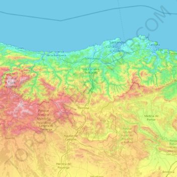
Name: Cantabria topographic map, elevation, terrain.
Location: Cantabria, Spain (42.75805 -4.85174 43.51362 -3.14965)
Average elevation: 609 m
Minimum elevation: -3 m
Maximum elevation: 2,603 m
Other topographic maps
Click on a map to view its topography, its elevation and its terrain.
Pyrenees
The Pyrenees are a mountain range straddling the border of France and Spain. They extend nearly 500 km (310 mi) from their union with the Cantabrian Mountains to Cap de Creus on the Mediterranean coast, reaching a maximum altitude of 3,404 metres (11,168 ft) at the peak of Aneto.
Average elevation: 491 m
Montenegral Alto
Spain > Andalusia > Campo de Gibraltar > San Martín del Tesorillo
Average elevation: 71 m
Soil
Spain > Autonomous Community of the Basque Country > Montaña Alavesa/Arabako Mendialdea
Average elevation: 898 m
Penyagolosa
Spain > Valencian Community > Castelló / Castellón > Xodos / Chodos
Average elevation: 1,417 m
Donostia / San Sebastián
Spain > Autonomous Community of the Basque Country > Donostialdea > Donostia / San Sebastián
Average elevation: 134 m
Madrid
Spain > Community of Madrid > Área metropolitana de Madrid y Corredor del Henares > Madrid
Average elevation: 650 m
Santiago de Compostela
Spain > Galicia > Santiago > Santiago de Compostela
The cathedral borders the main plaza of the old and well-preserved city. According to medieval legend, the remains of the apostle James were brought to Galicia for burial; in 813, the light of a bright star guided a shepherd who was watching his flock at night to the burial site in Santiago de Compostela. This…
Average elevation: 248 m