Geolocate

Sambong topographic map

Interactive map

Click on the map to display elevation.

About this map

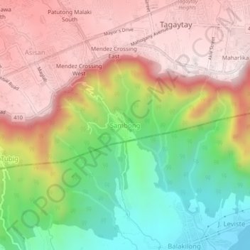
Name: Sambong topographic map, elevation, terrain.

Location: Sambong, Tagaytay, Cavite, Calabarzon, 4120, Philippines (14.06697 120.90364 14.10697 120.94364)

Average elevation: 371 m

Minimum elevation: 4 m

Maximum elevation: 691 m

Other topographic maps

Click on a map to view its topography, its elevation and its terrain.

Asisan

Philippines > Cavite > Tagaytay

Average elevation: 526 m

Maitim 2nd Central

Philippines > Cavite > Tagaytay

Average elevation: 561 m

Bagong Tubig

Philippines > Cavite > Tagaytay

Average elevation: 396 m

Calabuso

Philippines > Cavite > Tagaytay

Average elevation: 413 m

Mount Sungay

Philippines > Cavite > Tagaytay > Iruhin South

Mount Sungay is the eastern end of the Tagaytay Range, or more commonly known as the Tagaytay Ridge, a 32-kilometre (20 mi) ridge located at the southern part of the province with elevations averaging about 600 m (2,000 ft) above sea level. The ridge stretches west-southwest from Mount Sungay to Mount Batulao…

Average elevation: 501 m

Iruhin East

Philippines > Cavite > Tagaytay

Average elevation: 496 m

Tolentino West

Philippines > Cavite > Tagaytay

Average elevation: 522 m

Iruhin West

Philippines > Cavite > Tagaytay

Average elevation: 498 m

Iruhin South

Philippines > Cavite > Tagaytay

Average elevation: 450 m

Tagaytay Highlands

Philippines > Cavite > Tagaytay > Iruhin South

Average elevation: 428 m

Picnic Grove

Philippines > Cavite > Tagaytay > Iruhin West

Average elevation: 474 m

Kaybagal Central

Philippines > Cavite > Tagaytay

Average elevation: 581 m

Neogan

Philippines > Cavite > Tagaytay > Neogan

Average elevation: 488 m