
Thank you for supporting this site ❤️
Make a donation
Make a donation
Magat Dam topographic map
Click on the map to display elevation.
Thank you for supporting this site ❤️
Make a donation
Make a donation
About this map
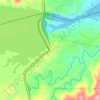
Name: Magat Dam topographic map, elevation, terrain.
Location: Magat Dam, Isabela, Cagayan Valley, Philippines (16.80412 121.44772 16.83477 121.45784)
Average elevation: 176 m
Minimum elevation: 104 m
Maximum elevation: 294 m
Thank you for supporting this site ❤️
Make a donation
Make a donation
Other topographic maps
Click on a map to view its topography, its elevation and its terrain.
Thank you for supporting this site ❤️
Make a donation
Make a donation
Thank you for supporting this site ❤️
Make a donation
Make a donation
Thank you for supporting this site ❤️
Make a donation
Make a donation
Roxas
The landscape of Roxas is relatively compose of flatlands with minimal rise at certain point with base mountain elevations on the eastern part, on the parts of Sinamar, Simimbaan and San Placido. It is approximately 90% of the land area comprising the town can be described as low-lying hills with rolling…
Average elevation: 59 m
Thank you for supporting this site ❤️
Make a donation
Make a donation