
Thank you for supporting this site ❤️
Make a donation
Make a donation
Williamson County topographic map
Click on the map to display elevation.
Thank you for supporting this site ❤️
Make a donation
Make a donation
About this map
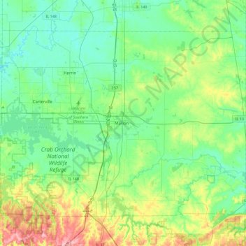
Name: Williamson County topographic map, elevation, terrain.
Location: Williamson County, Illinois, United States (37.59628 -89.15472 37.86441 -88.70679)
Average elevation: 146 m
Minimum elevation: 106 m
Maximum elevation: 262 m
Thank you for supporting this site ❤️
Make a donation
Make a donation
Other topographic maps
Click on a map to view its topography, its elevation and its terrain.
Sturbridge Village
United States > Illinois > Winnebago County > Sturbridge Village
Average elevation: 230 m
Thank you for supporting this site ❤️
Make a donation
Make a donation