
Thank you for supporting this site ❤️
Make a donation
Make a donation
Rotoiti topographic map
Click on the map to display elevation.
Thank you for supporting this site ❤️
Make a donation
Make a donation
About this map
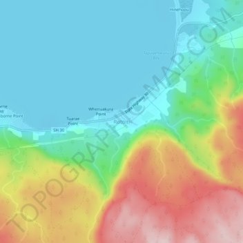
Name: Rotoiti topographic map, elevation, terrain.
Average elevation: 389 m
Minimum elevation: 280 m
Maximum elevation: 606 m
Rotorua Lakes District trails, hiking, mountain biking, running and outdoor activities
Thank you for supporting this site ❤️
Make a donation
Make a donation
Other topographic maps
Click on a map to view its topography, its elevation and its terrain.
Lake Rotoiti / Te Roto kite ā Ihenga i ariki ai Kahu
New Zealand > Bay of Plenty > Rotorua Lakes District > Okere Falls
Average elevation: 375 m