
Make a donation
Gibbston topographic map
Click on the map to display elevation.
Make a donation
About this map
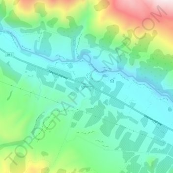
Name: Gibbston topographic map, elevation, terrain.
Location: Gibbston, Queenstown-Lakes District, Otago, New Zealand (-45.04329 168.93524 -45.00329 168.97524)
Average elevation: 491 m
Minimum elevation: 282 m
Maximum elevation: 1,045 m
Queenstown-Lakes District trails, hiking, mountain biking, running and outdoor activities
Make a donation
Other topographic maps
Click on a map to view its topography, its elevation and its terrain.
Lake Wakatipu
New Zealand > Otago > Queenstown-Lakes District
With a length of 80 kilometres (50 mi), it is New Zealand's longest lake, and, at 289 km2 (112 sq mi), its third largest. The lake is also very deep, its floor being below sea level (−110 metres), with a maximum depth of 420 metres (1,380 ft). It is at an altitude of 310 metres (1,020 ft), towards the…
Average elevation: 952 m
Lake Hāwea
New Zealand > Otago > Queenstown-Lakes District
Lake Hāwea is New Zealand's ninth largest lake located on the South Island in the Otago Region at an altitude of 348 m. It covers 141 km2 and is 392 m deep.
Average elevation: 864 m