
Thank you for supporting this site ❤️
Make a donation
Make a donation
Nye County topographic map
Click on the map to display elevation.
Thank you for supporting this site ❤️
Make a donation
Make a donation
Nye County
According to the U.S. Census Bureau, the county has an area of 18,199 square miles (47,140 km2), of which 18,182 square miles (47,090 km2) is land and 17 square miles (44 km2) (0.09%) is water. The highest and most topographically prominent mountain in the county is Mount Jefferson at 11,949 feet (3,642 m).
Thank you for supporting this site ❤️
Make a donation
Make a donation
About this map
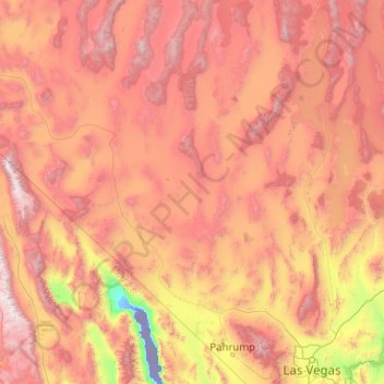
Name: Nye County topographic map, elevation, terrain.
Location: Nye County, Nevada, United States (35.96360 -118.19629 39.16336 -114.99899)
Average elevation: 1,620 m
Minimum elevation: -83 m
Maximum elevation: 4,193 m
Thank you for supporting this site ❤️
Make a donation
Make a donation
Other topographic maps
Click on a map to view its topography, its elevation and its terrain.
Cougar Creek Park
United States > Nevada > Clark County > Las Vegas > Enterprise
Average elevation: 771 m
Thank you for supporting this site ❤️
Make a donation
Make a donation
Thank you for supporting this site ❤️
Make a donation
Make a donation