
Make a donation
Buri Ram Province topographic map
Click on the map to display elevation.
Make a donation
About this map
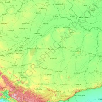
Name: Buri Ram Province topographic map, elevation, terrain.
Location: Buri Ram Province, Thailand (14.13004 102.43264 15.79583 103.50544)
Average elevation: 205 m
Minimum elevation: 25 m
Maximum elevation: 936 m
Make a donation
Other topographic maps
Click on a map to view its topography, its elevation and its terrain.
Make a donation
Khon Kaen
Khon Kaen is on the Khorat Plateau, elevation 187 m, and is the center of the mid-northeastern provincial group of Thailand, according to the Thai government. Its coordinates are 16°26′N 102°50′E / 16.433°N 102.833°E / 16.433; 102.833. The city municipality has a population of 114,459, while…
Average elevation: 165 m
Make a donation
Make a donation
Make a donation
Make a donation
Make a donation
Make a donation
Make a donation
Make a donation
Make a donation
Make a donation
Make a donation
Make a donation
Make a donation
Make a donation
Doi Inthanon
In 1954, the forests around Doi Inthanon were conserved, creating Doi Inthanon National Park, as one of the original 14 national parks of Thailand. This park now covers 482.4 km2 and spreads from the lowlands at 800 metres (2,625 ft) elevation up to the peak at 2,565 metres (8,415 ft). Given the varied…
Average elevation: 2,364 m
Make a donation
Make a donation
Phu Kradung
Thailand > Phu Kradueng District
Phu Kradueng National Park (Thai: อุทยานแห่งชาติภูกระดึง), in the Si Than sub-district of Amphoe Phu Kradueng, Loei Province, is a national park in Thailand. It has a high point of 1,316 m (4318 ft) elevation at Khok Moei. It was proclaimed a national park on 23…
Average elevation: 1,183 m
Make a donation
Make a donation
Make a donation
Make a donation
Make a donation
Make a donation
Make a donation
Make a donation