
Make a donation
Bandung topographic map
Click on the map to display elevation.
Make a donation
Bandung
Bandung (Sundanese: ᮊᮧᮒ ᮘᮔ᮪ᮓᮥᮀ, romanized: Kota Bandung, pronounced [ˈbandʊŋ]; /ˈbɑːndʊŋ/) is the capital city of West Java province of Indonesia. Located on the island of Java, Greater Bandung (Bandung Basin Metropolitan Area / BBMA) is the country's second-largest and most populous metropolitan area, with over 11 million inhabitants. Situated 768 meters (2,520 feet) above sea level, the highest point in the North area with an altitude of 1,050 meters (3,445 feet) and the lowest in the South is 675 meters (2,215 feet) above sea level, approximately 140 kilometres (87 miles) southeast of Jakarta, Bandung has cooler year-round temperatures than most other Indonesian cities. The city lies on a river basin surrounded by volcanic mountains that provide a natural defence system, which was the primary reason for the Dutch East Indies government's plan to move the capital from Batavia (modern-day Jakarta) to Bandung.
Make a donation
About this map
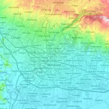
Name: Bandung topographic map, elevation, terrain.
Location: Bandung, West Java, Java, Indonesia (-6.96975 107.54536 -6.83685 107.73952)
Average elevation: 830 m
Minimum elevation: 643 m
Maximum elevation: 1,634 m
Make a donation
Other topographic maps
Click on a map to view its topography, its elevation and its terrain.