
Sagpura topographic map
Interactive map
Click on the map to display elevation.
About this map
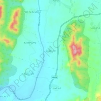
Name: Sagpura topographic map, elevation, terrain.
Location: Sagpura, Jhadol Tehsil, Udaipur District, Rajasthan, India (24.37760 73.41567 24.41760 73.45567)
Average elevation: 536 m
Minimum elevation: 486 m
Maximum elevation: 713 m
Other topographic maps
Click on a map to view its topography, its elevation and its terrain.
Kunda
India > Rajasthan > Jhadol Tehsil
Kunda, Jhadol Tehsil, Udaipur District, Rajasthan, India
Average elevation: 507 m
Kundal
India > Rajasthan > Jhadol Tehsil > Kundal
Kundal, Jhadol Tehsil, Udaipur District, Rajasthan, India
Average elevation: 667 m
Kherad
India > Rajasthan > Jhadol Tehsil
Kherad, Jhadol Tehsil, Udaipur District, Rajasthan, India
Average elevation: 542 m
Kanakpura
India > Rajasthan > Jhadol Tehsil
Kanakpura, Jhadol Tehsil, Udaipur District, Rajasthan, India
Average elevation: 556 m