
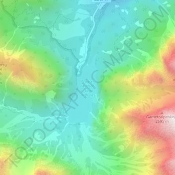
Pragser Wildsee topographic map
Interactive map
Click on the map to display elevation.
About this map
Name: Pragser Wildsee topographic map, elevation, terrain.
Average elevation: 1,744 m
Minimum elevation: 1,425 m
Maximum elevation: 2,444 m
Der See liegt auf 1494 m s.l.m. Höhe und hat eine Wasserfläche von 31 Hektar. Er ist durchschnittlich 17 Meter tief und weist eine maximale Tiefe von 36 Metern auf. Der geologische Ursprung des Sees ist auf die Entstehung eines natürlichen Staudammes infolge eines Murenabgangs zurückzuführen. Der See wird beherrscht vom imposanten Massiv des Seekofels (2810 m). Der See ist Ausgangspunkt des Dolomiten-Höhenweges Nr. 1.
Other topographic maps
Click on a map to view its topography, its elevation and its terrain.
Schmieden
Italien > Trentino-Südtirol > Bozen > Prags
Schmieden, Prags, Pustertal, Bozen, Trentino-Südtirol, 39039, Italien
Average elevation: 1,426 m