Geolocate

Macomb County topographic map

Interactive map

Click on the map to display elevation.

About this map

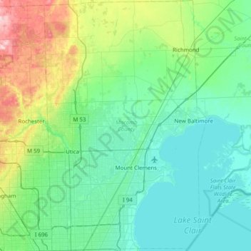
Name: Macomb County topographic map, elevation, terrain.

Location: Macomb County, Michigan, United States (42.44718 -83.10289 42.89754 -82.70597)

Average elevation: 208 m

Minimum elevation: 171 m

Maximum elevation: 371 m

Other topographic maps

Click on a map to view its topography, its elevation and its terrain.

Osseo

United States > Michigan > Hillsdale County

Average elevation: 340 m

Southfield

United States > Michigan > Oakland County

Average elevation: 210 m

Ann Arbor

United States > Michigan > Washtenaw County

The landscape of Ann Arbor consists of hills and valleys, with the terrain becoming steeper near the Huron River. The elevation ranges from about 750 feet (230 m) along the Huron River to 1,015 feet (309 m) on the city's west side, near the intersection of Maple Road and Pauline Blvd. Ann Arbor Municipal…

Average elevation: 272 m

Detroit

United States > Michigan > Wayne County

The city slopes gently from the northwest to southeast on a till plain composed largely of glacial and lake clay. The most notable topographical feature in the city is the Detroit Moraine, a broad clay ridge on which the older portions of Detroit and Windsor are located, rising approximately 62 feet (19 m)…

Average elevation: 187 m

Grand Rapids

United States > Michigan > Kent County

Grand Rapids developed on the banks of the Grand River, where there was once a set of rapids, at an altitude of 610 feet (186 m) above sea level. Ships could navigate on the river up to this fall line, stopping because of the rapids. The river valley is flat and narrow, surrounded by steep hills and bluffs.…

Average elevation: 216 m

Flint

United States > Michigan > Genesee County

Average elevation: 236 m

Clarksville

United States > Michigan > Ionia County

Average elevation: 255 m

Fennville

United States > Michigan > Allegan County

Average elevation: 204 m

Genesee County

United States > Michigan

Average elevation: 246 m

Pellston

United States > Michigan > Pellston

Average elevation: 212 m

Hawks

United States > Michigan > Hawks

Average elevation: 250 m

Roscommon County

United States > Michigan

Average elevation: 356 m

Pontiac

United States > Michigan > Pontiac

Average elevation: 290 m

Westland

United States > Michigan > Westland

Average elevation: 202 m

Antrim County

United States > Michigan

Average elevation: 276 m

Croswell

United States > Michigan > Croswell

Average elevation: 226 m

Plymouth

United States > Michigan > Plymouth

Average elevation: 223 m

Pinconning Township

United States > Michigan

Average elevation: 185 m

Clare County

United States > Michigan

Average elevation: 321 m

East Lansing

United States > Michigan > Ingham County

Average elevation: 261 m