
Thank you for supporting this site ❤️
Make a donation
Make a donation
West Devon topographic map
Click on the map to display elevation.
Thank you for supporting this site ❤️
Make a donation
Make a donation
About this map
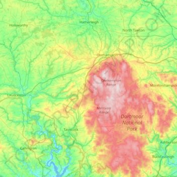
Name: West Devon topographic map, elevation, terrain.
Location: West Devon, Devon, England, United Kingdom (50.42937 -4.33510 50.87462 -3.73227)
Average elevation: 200 m
Minimum elevation: -2 m
Maximum elevation: 612 m
Thank you for supporting this site ❤️
Make a donation
Make a donation
Other topographic maps
Click on a map to view its topography, its elevation and its terrain.
Haytor Rocks
United Kingdom > England > Devon > Teignbridge > Haytor Vale > Smallacombe
Average elevation: 354 m
Thank you for supporting this site ❤️
Make a donation
Make a donation