
Roborough topographic map
Click on the map to display elevation.
About this map
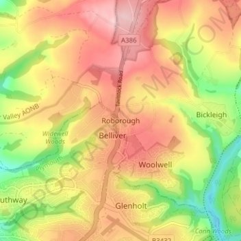
Name: Roborough topographic map, elevation, terrain.
Location: Roborough, South Hams, Devon, England, PL6 7BG, United Kingdom (50.42111 -4.12813 50.46111 -4.08813)
Average elevation: 123 m
Minimum elevation: 22 m
Maximum elevation: 200 m
Other topographic maps
Click on a map to view its topography, its elevation and its terrain.
Ivybridge
United Kingdom > England > Devon > South Hams
The topography of Ivybridge is generally hilly. This is because of the River Erme which flows right through the centre of town. To the east and to the west of the river the land is elevated forming a valley. The river first enters the town at 300 feet (91 m) above sea level and leaves the town at 130 feet (40…
Average elevation: 114 m