
Thank you for supporting this site ❤️
Make a donation
Make a donation
Malborough topographic map
Click on the map to display elevation.
Thank you for supporting this site ❤️
Make a donation
Make a donation
About this map
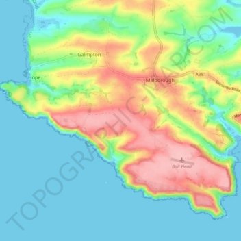
Name: Malborough topographic map, elevation, terrain.
Location: Malborough, South Hams, Devon, England, United Kingdom (50.20958 -3.85258 50.25764 -3.76118)
Average elevation: 45 m
Minimum elevation: -2 m
Maximum elevation: 134 m
Thank you for supporting this site ❤️
Make a donation
Make a donation
Other topographic maps
Click on a map to view its topography, its elevation and its terrain.