
Thank you for supporting this site ❤️
Make a donation
Make a donation
Tama County topographic map
Click on the map to display elevation.
Thank you for supporting this site ❤️
Make a donation
Make a donation
About this map
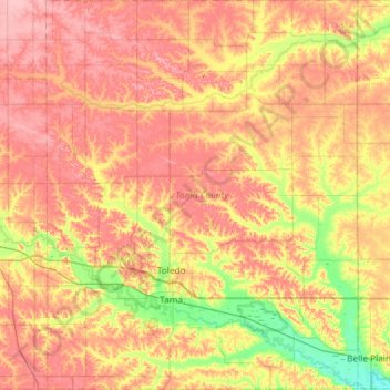
Name: Tama County topographic map, elevation, terrain.
Location: Tama County, Iowa, United States (41.86220 -92.76808 42.29753 -92.29764)
Average elevation: 287 m
Minimum elevation: 231 m
Maximum elevation: 334 m
Thank you for supporting this site ❤️
Make a donation
Make a donation
Other topographic maps
Click on a map to view its topography, its elevation and its terrain.
Cromwell;Cromwell Post Office
United States > Iowa > Union County > Cromwell > Cromwell;Cromwell Post Office
Average elevation: 387 m