
Make a donation
Kigoma Region topographic map
Click on the map to display elevation.
Make a donation
Kigoma Region
Kigoma Region is on a plateau that slopes from the northeast at about 1,750 metres (5,740 ft) down to 800 metres (2,600 ft) at the shore of lake Tanganyika. The topography in the north and east is gently rolling hills that gradually become steeper as they get closer to the Albertine Rift margin. The most important river is the Malagarasi, with the Luiche and the Ruchugi being the two other major rivers draining the region.
Make a donation
About this map
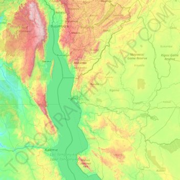
Name: Kigoma Region topographic map, elevation, terrain.
Location: Kigoma Region, Western Zone, Tanzania (-6.57282 29.59467 -2.83045 31.49326)
Average elevation: 1,215 m
Minimum elevation: 655 m
Maximum elevation: 3,421 m
Make a donation
Other topographic maps
Click on a map to view its topography, its elevation and its terrain.
Uhuru Peak
Kilimanjaro is the fourth most topographically prominent peak on Earth. It is part of Kilimanjaro National Park and is a major hiking and climbing destination. Because of its shrinking glaciers and ice fields, which are projected to disappear between 2025 and 2035, it has been the subject of many scientific…
Average elevation: 5,494 m
Make a donation
Make a donation
Arusha
Despite its proximity to the equator, Arusha's elevation of 1,400 metres (4,600 ft) on the southern slopes of Mount Meru keeps temperatures relatively low and alleviates humidity. Cool dry air is prevalent for much of the year. The temperature typically ranges between 10 and 30 °C (50 and 86 °F) with an…
Average elevation: 1,572 m
Make a donation