
Thank you for supporting this site ❤️
Make a donation
Make a donation
Waiatarua topographic map
Click on the map to display elevation.
Thank you for supporting this site ❤️
Make a donation
Make a donation
About this map
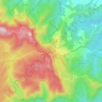
Name: Waiatarua topographic map, elevation, terrain.
Location: Waiatarua, Waitākere Ranges, Auckland, New Zealand (-36.95230 174.55816 -36.91230 174.59816)
Average elevation: 216 m
Minimum elevation: 49 m
Maximum elevation: 425 m
Auckland trails, hiking, mountain biking, running and outdoor activities
Thank you for supporting this site ❤️
Make a donation
Make a donation
Other topographic maps
Click on a map to view its topography, its elevation and its terrain.
Bethells Beach
New Zealand > Auckland > Waitakere Ranges > Te Henga / Bethells Beach
Average elevation: 33 m