
Queens topographic map
Interactive map
Click on the map to display elevation.
About this map
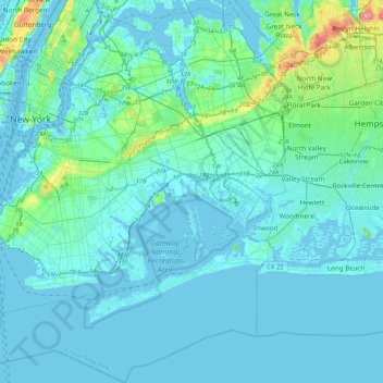
Name: Queens topographic map, elevation, terrain.
Location: Queens, New York, United States (40.54190 -73.96269 40.80092 -73.70018)
Average elevation: 12 m
Minimum elevation: -7 m
Maximum elevation: 109 m
Other topographic maps
Click on a map to view its topography, its elevation and its terrain.
Grasmere Lake
United States > New York > New York
Grasmere Lake, Staten Island, New York, United States
Average elevation: 27 m
Queens County
United States > New York > New York
Queens County, New York, United States
Average elevation: 11 m
New York County
United States > New York > New York
New York County, New York, United States
Average elevation: 16 m