
Cura Mori topographic map
Interactive map
Click on the map to display elevation.
About this map
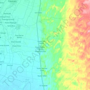
Name: Cura Mori topographic map, elevation, terrain.
Location: Cura Mori, Piura, Perú (-5.42798 -80.69923 -5.30033 -80.49653)
Average elevation: 46 m
Minimum elevation: 10 m
Maximum elevation: 148 m
Tiene una superficie territorial de 185 km² y se ubica en una altitud de 27 m.s.n.m.; en los 5°19¨ y 15¨ de latitud sur y 80° 39´ 45´ de longitud oeste. Está situado en la costa norte del Perú
Other topographic maps
Click on a map to view its topography, its elevation and its terrain.