
Make a donation
Signal Butte topographic map
Click on the map to display elevation.
Make a donation
About this map
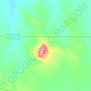
Name: Signal Butte topographic map, elevation, terrain.
Location: Signal Butte, South Dakota, United States (45.03660 -102.42299 45.03670 -102.42289)
Average elevation: 841 m
Minimum elevation: 807 m
Maximum elevation: 920 m
Make a donation
Other topographic maps
Click on a map to view its topography, its elevation and its terrain.
Pine Ridge Indian Reservation
The topography is generally rolling mixed grass prairie, interspersed in various location, especially to the north, into typical badlands topography. The higher elevations of the prairie are covered by wind blown sands that form dunes, blowouts, and thin sheets. The southern part of the reservation is crossed…
Average elevation: 912 m
Custer
United States > South Dakota > Custer County
Winter weather is dominated by the conflict between cold Arctic air moving south from Canada, and very warm chinook winds which can produce exceptionally high winter temperatures for the latitude and altitude. For instance, January 19 of 1963 saw the coldest temperature ever of −43 °F (−41.7 °C), yet in…
Average elevation: 1,660 m
Make a donation
Make a donation
Sylvan Lake
United States > South Dakota > Custer County > Sylvan Lake Resort
Average elevation: 1,891 m
Make a donation
Make a donation
Make a donation
Make a donation
Make a donation
Make a donation
Summit
United States > South Dakota > Roberts County
Summit was laid out in 1892, and was so named on account of the town site's lofty elevation.
Average elevation: 609 m
Kirby Dog Park at Fort Sod
United States > South Dakota > Minnehaha County > Sioux Falls
Average elevation: 441 m
Make a donation
Make a donation
Mina Lake Recreation Area
United States > South Dakota > Edmunds County > Mina
Average elevation: 435 m
Make a donation
Highmore
United States > South Dakota > Hyde County
A post office called Highmore has been in operation since 1882. The city was named from its lofty elevation.
Average elevation: 573 m
Make a donation
Make a donation
Make a donation
Brooking Municipal Utilitys
United States > South Dakota > Brookings County > Brookings
Average elevation: 492 m
Make a donation
Make a donation
Make a donation
Make a donation
Make a donation
Make a donation
Make a donation
Make a donation
Make a donation
Make a donation
Make a donation