
Thank you for supporting this site ❤️
Make a donation
Make a donation
Osgodby topographic map
Click on the map to display elevation.
Thank you for supporting this site ❤️
Make a donation
Make a donation
About this map
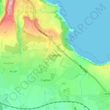
Name: Osgodby topographic map, elevation, terrain.
Location: Osgodby, North Yorkshire, England, YO11 3PT, United Kingdom (54.22425 -0.39801 54.26425 -0.35801)
Average elevation: 43 m
Minimum elevation: 0 m
Maximum elevation: 143 m
Thank you for supporting this site ❤️
Make a donation
Make a donation
Other topographic maps
Click on a map to view its topography, its elevation and its terrain.
Thank you for supporting this site ❤️
Make a donation
Make a donation
Thimbleby & Osmotherly Show field
United Kingdom > England > North Yorkshire > Thimbleby
Average elevation: 152 m
Thank you for supporting this site ❤️
Make a donation
Make a donation