
Thank you for supporting this site ❤️
Make a donation
Make a donation
Hungen topographic map
Click on the map to display elevation.
Thank you for supporting this site ❤️
Make a donation
Make a donation
About this map
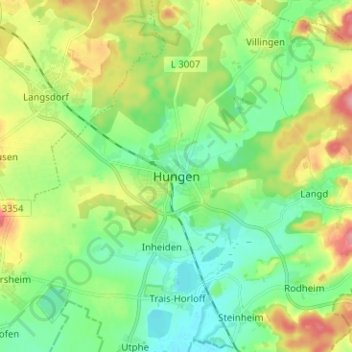
Name: Hungen topographic map, elevation, terrain.
Location: Hungen, Landkreis Gießen, Hesse, 35410, Germany (50.43525 8.86099 50.51525 8.94099)
Average elevation: 160 m
Minimum elevation: 125 m
Maximum elevation: 227 m
Thank you for supporting this site ❤️
Make a donation
Make a donation
Other topographic maps
Click on a map to view its topography, its elevation and its terrain.
Thank you for supporting this site ❤️
Make a donation
Make a donation
Thank you for supporting this site ❤️
Make a donation
Make a donation
Grünberg
Germany > Hesse > Landkreis Gießen
This is a scan of the historical document: Title: Grünberg - Topographia Hassiae language: German
Average elevation: 286 m