Geolocate

Salawagan topographic map

Interactive map

Click on the map to display elevation.

About this map

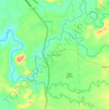
Name: Salawagan topographic map, elevation, terrain.

Location: Salawagan, Bukidnon, Northern Mindanao, 8715, Philippines (7.68413 125.09590 7.72413 125.13590)

Average elevation: 281 m

Minimum elevation: 234 m

Maximum elevation: 367 m

Other topographic maps

Click on a map to view its topography, its elevation and its terrain.

Lake Apo

Philippines > Bukidnon > Valencia

Lake Apo is a crater lake in Barangay Guinoyoran in the city of Valencia in Bukidnon province in the Philippines. It is located in a hilly area about 640 metres (2,100 ft) in elevation, about 11 kilometres (6.8 mi) WSW of the city poblacion (town center). Lake Apo was awarded the cleanest inland body of water…

Average elevation: 643 m

Impasugong

Philippines > Bukidnon

Impasugong is cool and moist throughout the year due to its high elevation ranging from 500 metres (1,600 ft) to more than 1,000 metres (3,300 ft) above sea level. It is a typhoon-free area ideal for the production of high-value crops. Average temperature ranges from 16 to 31 °C (61 to 88 °F) throughout the…

Average elevation: 903 m

Manolo Fortich

Philippines > Bukidnon

Average elevation: 712 m

Kadingilan

Philippines > Bukidnon

Average elevation: 286 m

Malitbog

Philippines > Bukidnon

Being naturally characterized by mountains and hilly terrain, slope ranging from 30 to 50 percent and above are therefore the most prevalent category. These are the steep to very steep slope found mostly in mountains areas. The largest part which can be found at the north and north-eastern part having an…

Average elevation: 472 m

Cabanglasan

Philippines > Bukidnon

The major part of the municipality is classified under slope class 8 to 15 per cent. Where such areas are found, it is contiguous to level areas, identified as water retaining areas potentially suited to intensive palay production. Along its North, East and South boundaries are slope class 30% and above, hilly…

Average elevation: 605 m

Sumilao

Philippines > Bukidnon

Average elevation: 1,001 m

Kalilangan

Philippines > Bukidnon

Average elevation: 860 m

Damulog

Philippines > Bukidnon

Average elevation: 210 m

Kaanibungan Ridge

Philippines > Bukidnon > Impasugong

Average elevation: 723 m

Baungon

Philippines > Bukidnon

Average elevation: 615 m

Kibawe

Philippines > Bukidnon

Kibawe is a rich land at the center of Mindanao, located in southern Bukidnon. It is bounded in the north by the municipality of Dangcagan, on the south by the municipality of Damulog, on the east by the municipality of Magpet, North Cotabato, and on the west by the municipality of Kadingilan with Muleta River…

Average elevation: 267 m

Dangcagan

Philippines > Bukidnon

It has a fertile soil ranging from clay to sandy loam. Its topography is 70% flat and 30% rolling, which is suitable for agricultural crops such as corn, rice and other commercial crops like coconut, coffee, cacao, rubber, banana and sugar cane.

Average elevation: 322 m

San Fernando

Philippines > Bukidnon

Average elevation: 665 m

Salug River

Philippines > Bukidnon > San Fernando > Santo Domingo

Average elevation: 722 m

Bobonawan River

Philippines > Bukidnon > Cabanglasan

Average elevation: 502 m

Malaybalay

Philippines > Bukidnon

The average elevation of the city is 622 metres (2,041 ft) above sea level. About 60% of the city's area has above 30% slope, characterized by steep hills, mountains, and cliff-like stream side. About 25% are level, gently sloping, and undulating. The rest are rolling and hilly.

Average elevation: 851 m

Sawaga River

Philippines > Bukidnon > Malaybalay > Casisang

Average elevation: 578 m

Valencia

Philippines > Bukidnon

The city's topography is characterized as flat to undulating hills with extensive plateaus and mountainous areas and cliffs on both eastern and western portions bounding the municipality of San Fernando on the east and the municipality of Talakag on the west. Its highest point is Mount Kalatungan in the…

Average elevation: 736 m

Pangantucan

Philippines > Bukidnon

Average elevation: 749 m

Kitaotao

Philippines > Bukidnon

Average elevation: 411 m

Maramag

Philippines > Bukidnon

Average elevation: 537 m

Talakag

Philippines > Bukidnon

Average elevation: 949 m

Lantapan

Philippines > Bukidnon

Average elevation: 996 m

Pulangi Lake

Philippines > Bukidnon > Panadtalan

Average elevation: 301 m