
Make a donation
Damulog topographic map
Click on the map to display elevation.
Make a donation
About this map
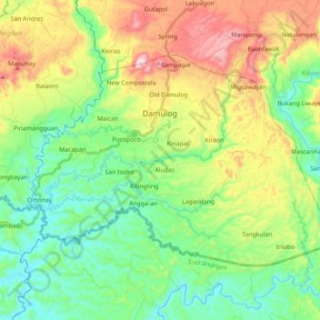
Name: Damulog topographic map, elevation, terrain.
Location: Damulog, Bukidnon, Northern Mindanao, 8721, Philippines (7.40326 124.87384 7.51923 125.05106)
Average elevation: 210 m
Minimum elevation: 34 m
Maximum elevation: 546 m
Make a donation
Other topographic maps
Click on a map to view its topography, its elevation and its terrain.
Mount Dulang-Dulang
Philippines > Bukidnon > Sumilao
Mount Dulang-dulang, dubbed by Filipino mountaineers as "D2" and also known as Mount Katanglad, is the highest elevation peak in the Kitanglad Mountain Range, located in the north central portion of the province of Bukidnon in the island of Mindanao. It is the second highest mountain of the Philippines at…
Average elevation: 2,448 m
Make a donation
Mount Kitanglad
Philippines > Bukidnon > Impasugong
Due to its high elevation, several communications and broadcasting companies constructed relay stations at the summit.
Average elevation: 2,393 m
Make a donation
Lake Apo
Philippines > Bukidnon > Valencia
Lake Apo is a crater lake in Barangay Guinoyoran in the city of Valencia in Bukidnon province in the Philippines. It is located in a hilly area about 640 metres (2,100 ft) in elevation, about 11 kilometres (6.8 mi) WSW of the city poblacion (town center). Lake Apo was awarded the cleanest inland body of water…
Average elevation: 643 m
Make a donation
Make a donation
Make a donation
Make a donation
Make a donation