
Thank you for supporting this site ❤️
Make a donation
Make a donation
Cheatham County topographic map
Click on the map to display elevation.
Thank you for supporting this site ❤️
Make a donation
Make a donation
About this map
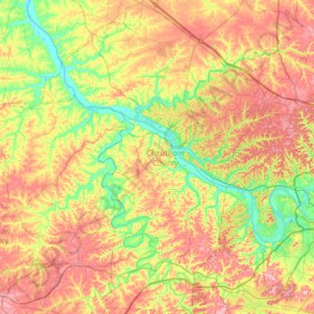
Name: Cheatham County topographic map, elevation, terrain.
Location: Cheatham County, Middle Tennessee, Tennessee, United States (36.04131 -87.28896 36.45569 -86.90959)
Average elevation: 189 m
Minimum elevation: 113 m
Maximum elevation: 286 m
Thank you for supporting this site ❤️
Make a donation
Make a donation
Other topographic maps
Click on a map to view its topography, its elevation and its terrain.
Thank you for supporting this site ❤️
Make a donation
Make a donation
Thank you for supporting this site ❤️
Make a donation
Make a donation
Shepherd
United States > Tennessee > Hamilton County > Chattanooga > Shepherd
Average elevation: 212 m
Thank you for supporting this site ❤️
Make a donation
Make a donation