Geolocate

Elkhart County topographic map

Interactive map

Click on the map to display elevation.

About this map

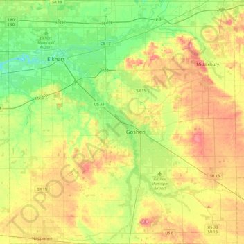
Name: Elkhart County topographic map, elevation, terrain.

Location: Elkhart County, Indiana, United States (41.43539 -86.06258 41.76052 -85.65353)

Average elevation: 254 m

Minimum elevation: 214 m

Maximum elevation: 307 m

Other topographic maps

Click on a map to view its topography, its elevation and its terrain.

Tell City

United States > Indiana > Perry County

Average elevation: 130 m

Wayne County

United States > Indiana

According to the 2010 census, the county has a total area of 404.34 square miles (1,047.2 km2), of which 401.74 square miles (1,040.5 km2) (or 99.36%) is land and 2.60 square miles (6.7 km2) (or 0.64%) is water. Wayne County includes Indiana's highest natural elevation, Hoosier Hill, at 1,257 feet (383 m).

Average elevation: 322 m

Putnam County

United States > Indiana

Average elevation: 243 m

Michigan City

United States > Indiana > LaPorte County

Average elevation: 188 m

South Bend

United States > Indiana > Saint Joseph County

On September 29, 1929, South Bend completed its "track elevation program". This was a railroad infrastructure project which saw the removal of Grand Trunk Western Railroad tracks from Division Street, the removal of level crossings from Chapin to Miami streets, the creation of a modern freight layout, and the…

Average elevation: 236 m

Perry County

United States > Indiana

Average elevation: 166 m

Geneva

United States > Indiana > Adams County

Average elevation: 258 m

Centerton

United States > Indiana > Morgan County

Average elevation: 201 m

Hammond

United States > Indiana > Hammond > Hammond

The city's elevation above sea level ranges from 577 feet (176 m) to 610 feet (186 m). The city sits within the boundaries of the former Lake Chicago, and much of its land area consists of former dune and swale terrain that was subsequently leveled. Most of the city is on sandy soil with a layer of black…

Average elevation: 180 m

Santa Fe

United States > Indiana > Spencer County > Santa Claus > Santa Fe

Average elevation: 139 m

Patoka

United States > Indiana > Gibson County

Average elevation: 134 m

Evansville

United States > Indiana > Evansville

Average elevation: 122 m

Brendonwood

United States > Indiana > Indianapolis > Brendonwood

Average elevation: 248 m

Bloomington

United States > Indiana > Bloomington

Bloomington is an area of irregular limestone terrain characterized by sinks, ravines, fissures, underground streams, sinking streams, springs and caves. It is in the rolling hills of southern Indiana, resting on the intersection of the Norman Uplands and the Mitchell Plain. The city's relatively varied…

Average elevation: 241 m

Mount Etna

United States > Indiana > Huntington County

Average elevation: 245 m