
Thank you for supporting this site ❤️
Make a donation
Make a donation
Kilve topographic map
Click on the map to display elevation.
Thank you for supporting this site ❤️
Make a donation
Make a donation
About this map
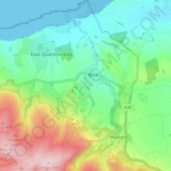
Name: Kilve topographic map, elevation, terrain.
Location: Kilve, Somerset, England, United Kingdom (51.15497 -3.23163 51.19739 -3.20096)
Average elevation: 100 m
Minimum elevation: 0 m
Maximum elevation: 317 m
Thank you for supporting this site ❤️
Make a donation
Make a donation
Other topographic maps
Click on a map to view its topography, its elevation and its terrain.