
Make a donation
Litchfield topographic map
Click on the map to display elevation.
Make a donation
About this map
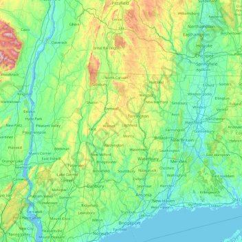
Name: Litchfield topographic map, elevation, terrain.
Location: Litchfield, Connecticut, 06750, United States (41.06725 -73.95430 42.46725 -72.55430)
Average elevation: 177 m
Minimum elevation: -4 m
Maximum elevation: 1,185 m
Make a donation
Other topographic maps
Click on a map to view its topography, its elevation and its terrain.
Hamden
United States > Connecticut > South Central Connecticut Planning Region
Average elevation: 64 m
Make a donation
East Haddam
United States > Connecticut > Lower Connecticut River Valley Planning Region
Average elevation: 96 m
Litchfield
United States > Connecticut > Northwest Hills Planning Region > Litchfield
Average elevation: 307 m
Waterford
United States > Connecticut > Southeastern Connecticut Planning Region
Average elevation: 30 m
Make a donation
Meriden
United States > Connecticut > South Central Connecticut Planning Region
Average elevation: 88 m
Wallingford
United States > Connecticut > South Central Connecticut Planning Region
Average elevation: 72 m
Make a donation
Ridgefield
United States > Connecticut > Western Connecticut Planning Region
Ridgefield consists of hilly, rocky terrain, ranging from 1,060 feet (320 m) above sea level (at Pine Mountain) to 342 feet (104 m) at Branchville. Its average village elevation is 725 feet (221 m) above sea level. The landscape is strewn with countless rocks deposited by glaciers, and among the town's bodies…
Average elevation: 183 m
Higganum
United States > Connecticut > Lower Connecticut River Valley Planning Region
Average elevation: 89 m
Make a donation