
Thank you for supporting this site ❤️
Make a donation
Make a donation
Fairview topographic map
Click on the map to display elevation.
Thank you for supporting this site ❤️
Make a donation
Make a donation
About this map
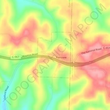
Name: Fairview topographic map, elevation, terrain.
Location: Fairview, Guernsey County, Ohio, 43736, United States (40.05195 -81.24054 40.06325 -81.22927)
Average elevation: 345 m
Minimum elevation: 282 m
Maximum elevation: 395 m
Thank you for supporting this site ❤️
Make a donation
Make a donation
Other topographic maps
Click on a map to view its topography, its elevation and its terrain.
Thank you for supporting this site ❤️
Make a donation
Make a donation
Thank you for supporting this site ❤️
Make a donation
Make a donation