
Drummond topographic map
Interactive map
Click on the map to display elevation.
About this map
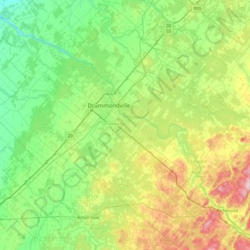
Name: Drummond topographic map, elevation, terrain.
Location: Drummond, Centre-du-Québec, Quebec, Canada (45.58941 -72.85400 46.09796 -72.09285)
Average elevation: 100 m
Minimum elevation: 4 m
Maximum elevation: 364 m
Other topographic maps
Click on a map to view its topography, its elevation and its terrain.
Lac Castor Weather Radar
Canada > Quebec > Mont-Valin
Each had until 2018 a range of 256 km (159 mi) in radius around the site to detect reflectivity, 3 angles with a range of 128 km (80 mi), for detecting velocity pattern (Doppler effect), and an extra long range at low elevation angle of 240 km (150 mi) but strongly folded for latter same purpose.
Average elevation: 719 m