
Thank you for supporting this site ❤️
Make a donation
Make a donation
General Luna topographic map
Click on the map to display elevation.
Thank you for supporting this site ❤️
Make a donation
Make a donation
About this map
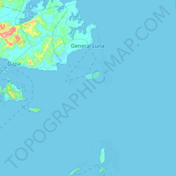
Name: General Luna topographic map, elevation, terrain.
Location: General Luna, Surigao del Norte, Caraga, 8419, Philippines (9.60212 126.10668 9.84524 126.18241)
Average elevation: 6 m
Minimum elevation: -1 m
Maximum elevation: 233 m
Thank you for supporting this site ❤️
Make a donation
Make a donation
Other topographic maps
Click on a map to view its topography, its elevation and its terrain.
Thank you for supporting this site ❤️
Make a donation
Make a donation
Thank you for supporting this site ❤️
Make a donation
Make a donation
Thank you for supporting this site ❤️
Make a donation
Make a donation