
Tahaenui River topographic map
Interactive map
Click on the map to display elevation.
About this map
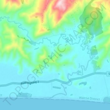
Name: Tahaenui River topographic map, elevation, terrain.
Average elevation: 75 m
Minimum elevation: 0 m
Maximum elevation: 408 m
Other topographic maps
Click on a map to view its topography, its elevation and its terrain.
Wairoa
New Zealand > Hawke's Bay > Wairoa District
Wairoa, Wairoa District, Hawke's Bay, 4108, New Zealand
Average elevation: 23 m
Nūhaka
New Zealand > Hawke's Bay > Wairoa District
Nūhaka, Wairoa District, Hawke's Bay, 4165, New Zealand
Average elevation: 31 m
Ohuka
New Zealand > Hawke's Bay > Wairoa District
Ohuka, Wairoa District, Hawke's Bay, 4195, New Zealand
Average elevation: 238 m
Mahia Beach
New Zealand > Hawke's Bay > Wairoa District > Mahia Beach
Mahia Beach, Wairoa District, Hawke's Bay, 4198, New Zealand
Average elevation: 37 m
Lake Waikaremoana
New Zealand > Hawke's Bay > Wairoa District
Lake Waikaremoana, Wairoa District, Hawke's Bay, New Zealand
Average elevation: 706 m