
Thank you for supporting this site ❤️
Make a donation
Make a donation
Tigray topographic map
Click on the map to display elevation.
Thank you for supporting this site ❤️
Make a donation
Make a donation
Tigray
Of the 10 largest cities in Tigray, Maychew has the highest elevation at 2479 meter above sea level. Plenty of smaller towns, like Atsbi and Edaga Hamus are located at even higher elevations. Of the large cities, Humera is located at the lowest altitude (585 m).
Thank you for supporting this site ❤️
Make a donation
Make a donation
About this map
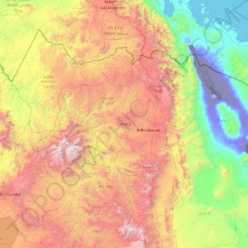
Name: Tigray topographic map, elevation, terrain.
Location: Tigray, Ethiopia (12.25628 36.44639 14.89434 39.99175)
Average elevation: 1,346 m
Minimum elevation: -126 m
Maximum elevation: 4,418 m
Thank you for supporting this site ❤️
Make a donation
Make a donation
Other topographic maps
Click on a map to view its topography, its elevation and its terrain.
Thank you for supporting this site ❤️
Make a donation
Make a donation
Thank you for supporting this site ❤️
Make a donation
Make a donation