
Thank you for supporting this site ❤️
Make a donation
Make a donation
Pune topographic map
Click on the map to display elevation.
Thank you for supporting this site ❤️
Make a donation
Make a donation
Pune
Pune lies on the western margin of the Deccan plateau, at an altitude of 560 m (1,840 ft) above sea level. It is on the leeward side of the Sahyadri mountain range, which forms a barrier from the Arabian Sea. It is a hilly city, with Vetal Hill rising to 800 m (2,600 ft) above sea level. The Sinhagad fort is at an altitude of 1,300 metres (4,300 feet).
Thank you for supporting this site ❤️
Make a donation
Make a donation
About this map
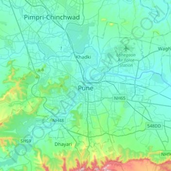
Name: Pune topographic map, elevation, terrain.
Location: Pune, Pune District, Maharashtra, India (18.42950 73.74985 18.62087 74.02021)
Average elevation: 616 m
Minimum elevation: 529 m
Maximum elevation: 1,138 m
Thank you for supporting this site ❤️
Make a donation
Make a donation
Other topographic maps
Click on a map to view its topography, its elevation and its terrain.