
Thank you for supporting this site ❤️
Make a donation
Make a donation
Howard County topographic map
Click on the map to display elevation.
Thank you for supporting this site ❤️
Make a donation
Make a donation
About this map
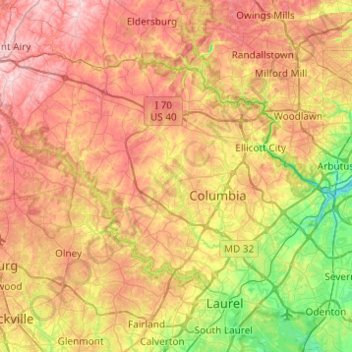
Name: Howard County topographic map, elevation, terrain.
Location: Howard County, Maryland, United States (39.10306 -77.18698 39.36954 -76.69636)
Average elevation: 128 m
Minimum elevation: 2 m
Maximum elevation: 266 m
Thank you for supporting this site ❤️
Make a donation
Make a donation
Other topographic maps
Click on a map to view its topography, its elevation and its terrain.
Thank you for supporting this site ❤️
Make a donation
Make a donation
Thank you for supporting this site ❤️
Make a donation
Make a donation
Piscataway Hills
United States > Maryland > Prince George's County > Fort Washington
Average elevation: 26 m
Thank you for supporting this site ❤️
Make a donation
Make a donation
Capitol Heights
United States > Maryland > Prince George's County > Capitol Heights > Capitol Heights
Average elevation: 51 m
Stoney Creek Pond
United States > Maryland > Montgomery County > Bethesda > Glenwood
Average elevation: 100 m