Geolocate

Franklin County topographic map

Interactive map

Click on the map to display elevation.

Franklin County

Franklin is one of Tennessee's southern tier of counties and abuts the Alabama border. It has a varied geography, extending from the southeast corner of the Nashville Basin over the Highland Rim and up onto the Cumberland Plateau, for a difference in elevation of about 1,300 feet (400 m). The county is well watered and forested, and except for the steeper areas of the plateau is well suited for agriculture, having a long growing season and mild winters.

Wikipedia (CC-BY-SA 3.0)

About this map

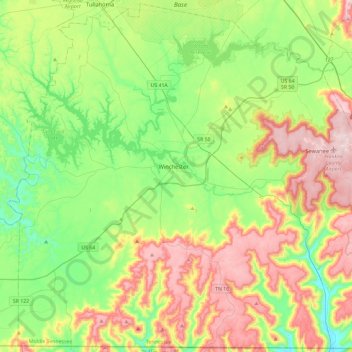
Name: Franklin County topographic map, elevation, terrain.

Location: Franklin County, Middle Tennessee, Tennessee, United States (34.98825 -86.33061 35.36289 -85.86328)

Average elevation: 349 m

Minimum elevation: 189 m

Maximum elevation: 620 m

Other topographic maps

Click on a map to view its topography, its elevation and its terrain.

Hickman County

United States > Tennessee

Average elevation: 213 m

Nashville-Davidson

United States > Tennessee > Davidson County

Nashville lies on the Cumberland River in the northwestern portion of the Nashville Basin. Nashville's elevation ranges from its lowest point, 385 feet (117 m) above sea level at the Cumberland River, to its highest point, 1,163 feet (354 m) above sea level in the Radnor Lake State Natural Area. Nashville also…

Average elevation: 184 m

Bradley County

United States > Tennessee

Average elevation: 261 m

Rhea County

United States > Tennessee

Average elevation: 378 m

Wales

United States > Tennessee > Giles County

Average elevation: 224 m

Livingston

United States > Tennessee > Overton County

According to the United States Census Bureau, the town has a total area of 5.2 square miles (13 km2), of which 5.1 square miles (13 km2) is land and 0.04 square miles (0.10 km2) (0.77%) is water. Elevation in the town ranges from 1,027 ft (313 m) to 1700 ft (518.16 m)

Average elevation: 349 m

Hampton

United States > Tennessee > Carter County

Average elevation: 674 m

Dickson

United States > Tennessee > Dickson County

Average elevation: 242 m

Cookeville

United States > Tennessee > Putnam County

Located on the Highland Rim, Cookeville's elevation (1100 ft AMSL) is a few hundred feet higher than either Nashville or Knoxville. As a result, temperatures and humidity levels are generally slightly lower in Cookeville than in either the Nashville Basin or in the Tennessee Valley.

Average elevation: 332 m

Ashland City

United States > Tennessee > Cheatham County

Average elevation: 166 m

Dandridge

United States > Tennessee > Jefferson County

Average elevation: 357 m

Sevier County

United States > Tennessee

The maximum elevation differential in Sevier County is the greatest in Tennessee, ranging from a high of 6,643 feet (2,025 m) at Clingmans Dome to a low of 850 feet (260 m) at the French Broad River.

Average elevation: 599 m

Dyersburg

United States > Tennessee > Dyer County

Average elevation: 93 m

Maynardville

United States > Tennessee > Union County

Average elevation: 408 m

Cheatham County

United States > Tennessee

Average elevation: 189 m

Memphis

United States > Tennessee > Shelby County

Average elevation: 81 m

Chestnut Mound

United States > Tennessee > Smith County

Average elevation: 260 m

Wilson County

United States > Tennessee

Average elevation: 191 m

Mount Vinson

United States > Tennessee > McNairy County

Average elevation: 131 m

Dante

United States > Tennessee > Knox County > Knoxville > Dante

Average elevation: 332 m

Chapel Hill

United States > Tennessee

Average elevation: 258 m

Humphreys County

United States > Tennessee

Average elevation: 174 m

Jackson

United States > Tennessee > Jackson

Average elevation: 129 m

Gatlinburg

United States > Tennessee > Sevier County

Average elevation: 577 m

Mount Juliet

United States > Tennessee > Mount Juliet

Average elevation: 169 m

Chattanooga

United States > Tennessee > Hamilton County

With a downtown elevation of about 680 feet (210 m), Chattanooga is at the transition between the ridge-and-valley portion of the Appalachian Mountains and the Cumberland Plateau. Its official nickname is "Scenic City", alluding to the surrounding by mountains and ridges. Unofficial nicknames include "River…

Average elevation: 331 m

Loudon County

United States > Tennessee

Average elevation: 281 m

Harrogate

United States > Tennessee > Harrogate

Average elevation: 416 m

Knoxville

United States > Tennessee > Knox County

According to the United States Census Bureau, the city has a total area of 104.2 square miles (269.8 km2), of which 98.5 square miles (255.2 km2) is land and 5.6 square miles (14.6 km2), or 5.42%, is water. Elevations range from just over 800 feet (240 m) along the riverfront to just over 1,000 feet (300 m) on…

Average elevation: 307 m