
Gaintza topographic map
Interactive map
Click on the map to display elevation.
About this map
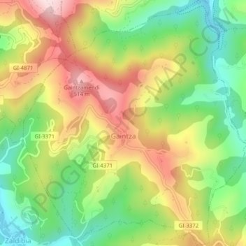
Name: Gaintza topographic map, elevation, terrain.
Average elevation: 327 m
Minimum elevation: 157 m
Maximum elevation: 528 m
Other topographic maps
Click on a map to view its topography, its elevation and its terrain.
Soil
Spain > Autonomous Community of the Basque Country > Montaña Alavesa/Arabako Mendialdea
Average elevation: 898 m
Donostia / San Sebastián
Spain > Autonomous Community of the Basque Country > Donostialdea > Donostia / San Sebastián
Average elevation: 134 m
Bilbao
Spain > Autonomous Community of the Basque Country > Bilbao
Bilbao is situated in the north-central part of Spain, some 16 kilometres (10 mi) south of the Bay of Biscay, where the economic social development is located, where the estuary of Bilbao is formed. Its main urban core is surrounded by two small mountain ranges with an average elevation of 400 metres (1,300…
Average elevation: 156 m