
Hyderabad topographic map
Interactive map
Click on the map to display elevation.
About this map
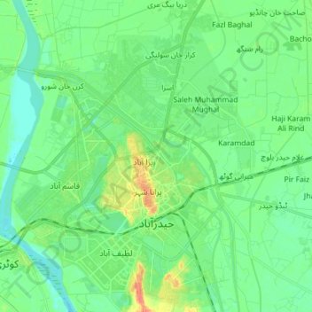
Name: Hyderabad topographic map, elevation, terrain.
Location: Hyderabad, Sindh, 91000, Pakistan (25.34346 68.31032 25.47114 68.42009)
Average elevation: 21 m
Minimum elevation: 10 m
Maximum elevation: 45 m
Other topographic maps
Click on a map to view its topography, its elevation and its terrain.
Karachi
Karachi lies very close to a major fault line, where the Indian tectonic plate meets the Arabian tectonic plate. Within the city of Karachi are two small ranges: the Khasa Hills and Mulri Hills, which lie in the northwest and act as a barrier between North Nazimabad and Orangi. Karachi's hills are barren and…
Average elevation: 20 m
Karachi
Within the city of Karachi are two small ranges: the Khasa Hills and Mulri Hills, which lie in the northwest and act as a barrier between North Nazimabad and Orangi. Karachi's hills are barren and are part of the larger Kirthar Range, and have a maximum elevation of 528 metres (1,732 feet).
Average elevation: 106 m
Hyderabad
Located at 25.367 °N latitude and 68.367 °E longitude with an elevation of 13 metres (43 ft), Hyderabad is located on the east bank of the Indus River and is roughly 150 kilometres (93 mi) away from Karachi, the provincial capital. Two of Pakistan's largest highways, the Indus Highway and the National…
Average elevation: 28 m