
Thank you for supporting this site ❤️
Make a donation
Make a donation
Dalhousie topographic map
Click on the map to display elevation.
Thank you for supporting this site ❤️
Make a donation
Make a donation
About this map
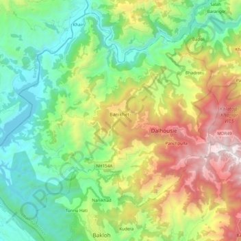
Name: Dalhousie topographic map, elevation, terrain.
Location: Dalhousie, Chamba, Himachal Pradesh, India (32.47001 75.83121 32.61554 76.02363)
Average elevation: 1,247 m
Minimum elevation: 490 m
Maximum elevation: 2,755 m
Thank you for supporting this site ❤️
Make a donation
Make a donation
Other topographic maps
Click on a map to view its topography, its elevation and its terrain.