
Make a donation
Yan'an topographic map
Click on the map to display elevation.
Make a donation
Yan'an
Yan'an is located in northern Shaanxi on the Loess Plateau, with a latitude spanning from 35°21′ to 37°31′ N, and a longitude spanning from 107°41′ t0 110°31′ E.[12] The city is bordered by Yulin to the north, Xianyang, Tongchuan, and Weinan in the Guanzhong region to the south, Linfen and Lüliang of Shanxi to the east across the Yellow River, and Qingyang of Gansu to the west across the Ziwu Ridge (Chinese: 子午岭).[12] The city's elevation is hilly, and is higher in the northwest, and lower in the southeast, ranging from 388 metres (1,273 ft) to 1,809 metres (5,935 ft) above sea level in elevation.[12] The average elevation of Yan'an is approximately 1,000 m (3,280 ft), and Yan'an's urban core has an elevation of about 960 metres (3,150 ft) above sea level.[12] In addition to the Yellow River flowing through Yan'an, the city's major rivers include the Yan River and the Luo River.[12]
Make a donation
About this map
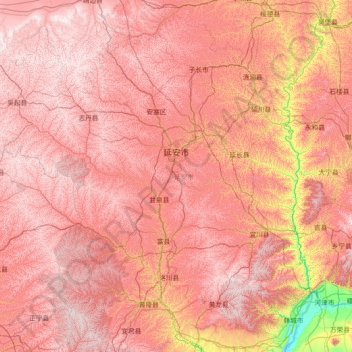
Name: Yan'an topographic map, elevation, terrain.
Location: Yan'an, Shaanxi, China (35.35145 107.65051 37.49958 110.54643)
Average elevation: 1,186 m
Minimum elevation: 355 m
Maximum elevation: 1,819 m
Make a donation
Other topographic maps
Click on a map to view its topography, its elevation and its terrain.