
Thank you for supporting this site ❤️
Make a donation
Make a donation
Danfeng topographic map
Click on the map to display elevation.
Thank you for supporting this site ❤️
Make a donation
Make a donation
About this map
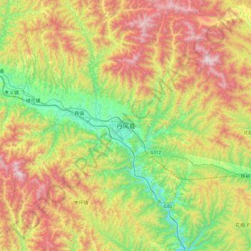
Name: Danfeng topographic map, elevation, terrain.
Location: Danfeng, Shangluo, Shaanxi, China (33.53610 110.16951 33.85610 110.48951)
Average elevation: 989 m
Minimum elevation: 459 m
Maximum elevation: 1,731 m
Thank you for supporting this site ❤️
Make a donation
Make a donation
Other topographic maps
Click on a map to view its topography, its elevation and its terrain.
Yan'an
Yan'an is located in northern Shaanxi on the Loess Plateau, with a latitude spanning from 35°21′ to 37°31′ N, and a longitude spanning from 107°41′ t0 110°31′ E.[12] The city is bordered by Yulin to the north, Xianyang, Tongchuan, and Weinan in the Guanzhong region to the south, Linfen and Lüliang…
Average elevation: 1,186 m