
Thank you for supporting this site ❤️
Make a donation
Make a donation
Pulau Singa Besar topographic map
Click on the map to display elevation.
Thank you for supporting this site ❤️
Make a donation
Make a donation
About this map
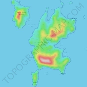
Name: Pulau Singa Besar topographic map, elevation, terrain.
Location: Pulau Singa Besar, Langkawi, Kedah, Malaysia (6.17794 99.72093 6.23377 99.75204)
Average elevation: 26 m
Minimum elevation: -1 m
Maximum elevation: 263 m
Thank you for supporting this site ❤️
Make a donation
Make a donation
Other topographic maps
Click on a map to view its topography, its elevation and its terrain.