
French Guiana topographic map
Interactive map
Click on the map to display elevation.
French Guiana
French Guiana has an equatorial climate predominant. Located within six degrees of the Equator and rising only to modest elevations, French Guiana is hot and oppressively humid all year round. During most of the year, rainfall across the country is heavy due to the presence of the Intertropical Convergence Zone and its powerful thunderstorm cells. In most parts of French Guiana, rainfall is always heavy especially from December to July – typically over 330 millimetres or 13 inches can be expected each month during this period throughout the department. Between August and November, the eastern half experiences a warm dry season with rainfall below 100 millimetres or 3.94 inches and average high temperatures above 30 °C (86 °F) occurring in September and October, causing eastern French Guiana to be classified as a tropical monsoon climate (Köppen Am); Saint-Laurent-du-Maroni in the west has a tropical rainforest climate (Af).
About this map
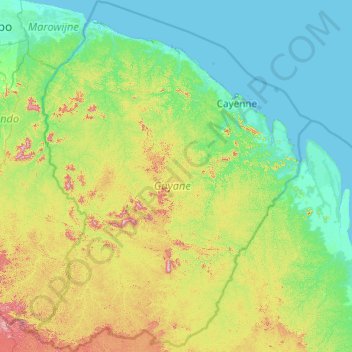
Name: French Guiana topographic map, elevation, terrain.
Location: French Guiana, France (2.11094 -54.60269 5.98389 -51.50452)
Average elevation: 96 m
Minimum elevation: -2 m
Maximum elevation: 791 m
Other topographic maps
Click on a map to view its topography, its elevation and its terrain.
18360
France > Centre-Val de Loire > Cher > Saulzais-le-Potier > Les Tonnelles
Average elevation: 227 m
20111
France > Corsica > South Corsica > Calcatoggio > Calcatoggio / Calcatoghju > Saint-Nicolas
Average elevation: 284 m
Laval
France > Pays de la Loire > Mayenne
Elevation varies between 42 and 122 meters above sea level. Laval is, in fact, a hilly town, marked by a rocky promontory dominating the valley of the Mayenne river. The castle was built on this promontory and the medieval centre spreads around. The promontory and the slightly hilly landscape around Laval are…
Average elevation: 87 m
Nantes
France > Pays de la Loire > Loire-Atlantique
Nantes is built on the Armorican Massif, a range of weathered mountains which may be considered the backbone of Brittany. The mountains, stretching from the end of the Breton peninsula to the outskirts of the sedimentary Paris Basin, are composed of several parallel ridges of Ordovician and Cadomian rocks.…
Average elevation: 26 m
Barricata
France > Nouvelle-Aquitaine > Pyrénées-Atlantiques > Aussurucq > Etxakokua
Average elevation: 260 m
Saint-Denis
The city is located on the north end of the island, and was a port. Saint-Denis was "originally the main port of Réunion, but an artificial harbour at Le Port, on the northwest coast, replaced it in the 1880s, because of unpredictable winds and tides at Saint-Denis." The city includes some of the island's…
Average elevation: 722 m