
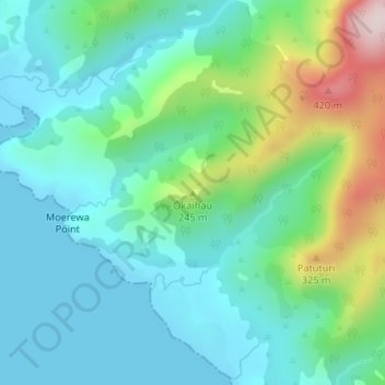
Okaihau topographic map
Interactive map
Click on the map to display elevation.
About this map
Name: Okaihau topographic map, elevation, terrain.
Average elevation: 107 m
Minimum elevation: 0 m
Maximum elevation: 442 m
Other topographic maps
Click on a map to view its topography, its elevation and its terrain.
Opononi
New Zealand > Northland > Far North District > Kaikohe-Hokianga Community
Opononi, Kaikohe-Hokianga Community, Far North District, Northland, 0444, New Zealand
Average elevation: 51 m
Rotokakahi
New Zealand > Northland > Far North District > Kaikohe-Hokianga Community
Rotokakahi, Kaikohe-Hokianga Community, Far North District, Northland, 0496, New Zealand
Average elevation: 90 m
Utakura River
New Zealand > Northland > Far North District > Kaikohe-Hokianga Community
Utakura River, Kaikohe-Hokianga Community, Far North District, Northland, New Zealand
Average elevation: 124 m
Runaruna
New Zealand > Northland > Far North District > Kaikohe-Hokianga Community
Runaruna, Kaikohe-Hokianga Community, Far North District, Northland, New Zealand
Average elevation: 81 m
Kaikohe
New Zealand > Northland > Far North District > Kaikohe-Hokianga Community
Kaikohe, Kaikohe-Hokianga Community, Far North District, Northland, 0405, New Zealand
Average elevation: 218 m
Tauwhare
New Zealand > Northland > Far North District > Kaikohe-Hokianga Community
Tauwhare, Kaikohe-Hokianga Community, Far North District, Northland, New Zealand
Average elevation: 281 m