
Thank you for supporting this site ❤️
Make a donation
Make a donation
Agusan River topographic map
Click on the map to display elevation.
Thank you for supporting this site ❤️
Make a donation
Make a donation
About this map
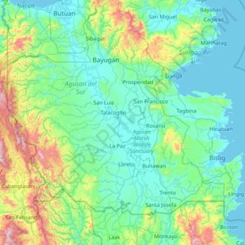
Name: Agusan River topographic map, elevation, terrain.
Location: Agusan River, Agusan del Sur, Caraga, 8604, Philippines (7.77887 125.51878 9.01349 126.07960)
Average elevation: 238 m
Minimum elevation: -1 m
Maximum elevation: 1,614 m
Thank you for supporting this site ❤️
Make a donation
Make a donation
Other topographic maps
Click on a map to view its topography, its elevation and its terrain.