
Thank you for supporting this site ❤️
Make a donation
Make a donation
Umarga topographic map
Click on the map to display elevation.
Thank you for supporting this site ❤️
Make a donation
Make a donation
About this map
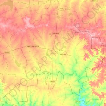
Name: Umarga topographic map, elevation, terrain.
Location: Umarga, Dharashiv District, Maharashtra, India (17.64159 76.38704 18.03842 76.79163)
Average elevation: 592 m
Minimum elevation: 489 m
Maximum elevation: 678 m
Thank you for supporting this site ❤️
Make a donation
Make a donation
Other topographic maps
Click on a map to view its topography, its elevation and its terrain.