
Make a donation
Harford County topographic map
Click on the map to display elevation.
Make a donation
Harford County
Harford County straddles the border between the rolling hills of the Piedmont Plateau and the flatlands of the Atlantic Coastal Plain along the Chesapeake Bay and its tributaries. The county's development is a mix of rural and suburban, with denser development in the larger towns of Aberdeen and Bel Air and along Route 40 and other major arteries leading out of Baltimore. The highest elevations are in the north and northwest of the county, reaching 805 ft. near the Pennsylvania border in the county's northwestern corner. The lowest elevation is sea level along the Chesapeake Bay.
Make a donation
About this map
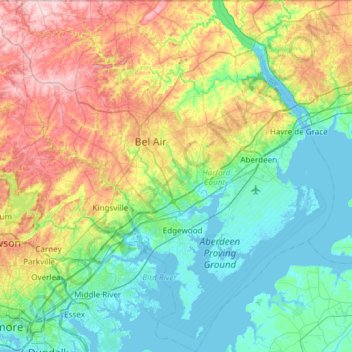
Name: Harford County topographic map, elevation, terrain.
Location: Harford County, Maryland, United States (39.25801 -76.56945 39.72121 -76.03564)
Average elevation: 70 m
Minimum elevation: -3 m
Maximum elevation: 237 m
Make a donation
Other topographic maps
Click on a map to view its topography, its elevation and its terrain.
Make a donation
Make a donation
Piscataway Hills
United States > Maryland > Prince George's County > Fort Washington
Average elevation: 26 m
Make a donation
Capitol Heights
United States > Maryland > Prince George's County > Capitol Heights > Capitol Heights
Average elevation: 51 m
Stoney Creek Pond
United States > Maryland > Montgomery County > Bethesda > Glenwood
Average elevation: 100 m